Growing Up in Hisar
II
In the 1960s,
Middle Hisar,
the area that the college occupied, was 50 families, of whom 25 were college
housing.
Actually, the college had an
official address of "Bebek" despite its
clearly being located in Hisar (well.. one entrance to the college campus was slightly closer to
Bebek than to Hisar, but
the campus itself was very much in Hisar.)
For most of the 60s, there was no
viable approach to Hisar from the upper/ridge which
is now Etiler. In the 60s, you could literally get
stranded in a snow storm trying to approach along the top of the hill from Etiler I know: it happened to me at least once, and it wasn’t
until the late 60s that (irregular) bus service began to HisarUstu
(
-------------
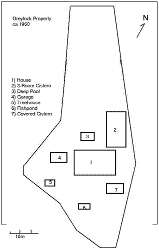
Greylock was built around the 1920s. I had originally
assume the name bore some relation to the massive gray stones that were used to
build the outer walls, but it appears that it actually came from the name of a mountain
in New England. It was one of several properties belonging to the "
The Greylock
property was ridiculously large, even for that place and time. There were more
than 5 distinct levels of land, each with fortress-like garden walls.
Separating the main property from the cobble-stone street that was its street
address (Fenerli Turbe Sokak - "street of the lamp(lit)
tomb(shrine)"), was a massive stone wall that reached heights of 30 feet
or more with a huge iron gate at the lower entrance. The entire property was
walled in except the farthest northwest reaches - and they were quite far. A
modern developer would easily fit 15 apartment blocks into the land, or 5 or
more luxury villas with decent gardens.
Story has it that the property was
once the domain of the "Crazy Pasha" of Hisar
who managed the water distribution rights for the village. There were cisterns buried
into every corner of the land: some were deep open pools (one which we
converted to a swimming pool), several buried into the earth, a well mounted by
a towering 30 foot metal framework windmill, and pumice-like stone structures
in the yard that were clearly water-playing features. The house itself, while
built much later than the water-pasha's home, included a subterranean water
storage room that was connected to a wooden hand pump about 3 feet in length
that could force water to the attic where there were collection barrels that
would provide gravitational down-flow to the kitchen and baths.
There were fruit trees throughout
the garden - most fairly native: more plums and plum varieties than you could
shake a stick at (and we shook many to get at the fruit) - perhaps 20 or so;
walnuts, kumquats, hazel nut trees, pines with nuts, grapes, a cherry, and
figs. There was a collection of other trees that included imported redwood
firs, "redbuds", magnolias of several varieties, oak, plain and
chestnut trees (of both the edible and non edible kind). In the first year we
lived there (1961) there was a gardener - it was more than a working family
could keep up with, what with the flower beds and such, but in our later years,
as the economy began to change, we had to manage the yard ourselves. In fact,
it was part of our weekly chores that each of us would tackle one of the many
corners of the "garden" every Saturday morning before we were
"free". Dad frequently hired various men to help out and I recall in
the late 60s his delight in telling visitors that he had Jesus and Paul (those
were their real names - Isa and Pavlos)
working in the yard. The garage to the side of the house was the size of a barn
but placed in such a way that it was useless for car access.
The house itself was near the top of
the Hisar hill and had about 15 rooms in its original
configuration which we and the Averys lived in at differnt times as single families in the early 60s. In the
mid-60s, the
At one point (before we moved in),
the back half of the property, which we never did really "control",
included a tennis court. The property was so big that it was virtually
impossible to "defend", even after we extended the outer walls to the
north: there were always animals wandering in. (Upper Hisar
was still primarily open farm land, and the visiting livestock included at
times stray cattle, a horse we allowed our farmer-neighbor to graze, sheep and
goats and of course feral dogs.) In the early 60s, the back northwest corner of
the property abutted a hilltop graveyard that must have been overflow from the
main lower 1452 Rumeli Hisar
castle graveyard: the tombstones were exquisite Ottoman carving and script -
and all over-run with thick low brush. Not a one of them remains today.
At another time in the late 60s, my
best friend and I contrived to make some use of the basically unused/wild back
section of the property by designing a "golf course". The area was
big enough that we managed 2 decent par-3 holes, heading out along the top section
and back down through the lower, but the ground cover was a bit
"rough" - to say the least:
thistles and no grass to speak of: not even on the "green". The point
being, however, that the length and width of the land was enough that you could
get in about 2 good "drives" with a 6 iron and still be within the
property.
One corner of the yard had a copse
of about 6 trees (I recall they were 50+ foot tall linden trees) rooted within
a few feet of each other. About 20 feet up off the ground, the Averys had built a tree house - nay, a fortress. The tree
house had a floor plan of 10 x 10 feet, and it was 2 stories high. There were
side walls, a trap door and the thing was so sturdy that it survived, with
minor repairs, more than a decade of heavy use. We strung wire from the house
through the trees (more than one set of wires went off into the woods and the
neighborhood), that at various times either provided electricity or
communications links. Another tree house that we later built in a nearby tree
never amounted to much more than a treetop perch platform: this first one was
superior, both for its natural configuration and its solid build.
One of the "levels" was
ideally suited as a vegetable garden. It was protected from traffic, being off
to the lower side of the house itself and accessible from the basement exit
door or a set of stone steps down from the "front" yard. Off to one
end of this garden was the walk-in entrance to one set of 3 or 4 of the covered
cisterns (one of which had a well-covered marble access from an upper level
yard behind the house.)
Although there were many other
beautiful yards in the neighborhood, I can't think of one that came close to
matching the grandeur, variety and natural riches of this one. Unfortunately, in the early 1990s. the
city claimed eminent domain, paid a ridiculous pittance, and took possession of
the house and land. Within 10 years, the place was falling apart. At one point,
when I visited, the doors were banging in the wind, rain had seeped in from the
attic exit left open and the floors were slowly rotting. Mildly mitigating this
condemnation of the city's management, the place has finally recently been
fixed up and "reclaimed" and is once again in service.
map by cedmonds
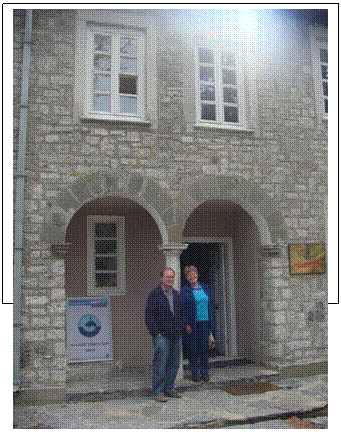
photo courtesy of Whit Shepard